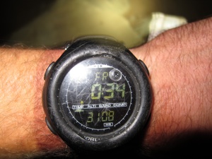
New CT Unsupported Record!

10D19H5M
Wednesday, September 5, 2012
Background
This year marks the 10th anniversary of myself exploring wild places on foot through long distance hiking. In 2003, in the early spring chill, I set off from Springer Mountain along my first long distance hike, the Appalachian Trail. Truly a life changing event, in subsequent years I have been building upon the lessons I learned over the course of those 5 months, finding more broad and complex ways to challenge myself in an effort to continue that learning process. The mountains have taken me to new heights, new States, new Countries and new terrains. As with each new trip, I try and find someway of further pushing my own comfort circles and inner boundaries. That is why I chose the Colorado Trail as my latest challenge for this milestone year.
The idea of trying a hike for speed has been rolling around in my head for a few years now. I guess I’m a fast hiker naturally, but I do love to take days off here and then and spend time in the luxuries of trail towns, so I’ve never really had a focus on seeing how far and how fast I could go in one push. The other factor that went into my decision to try for the Unsupported CT record is that the Colorado Trail has been on my short list of trails I’ve been wanting to revisit for some time now. Ever since heading through that corridor during my 2006 CDT thru-hike, I always wondered where the ‘other’ trail led after diverging from one another. The idea of starting a hike in a major city, Denver, is both as appealing logistically as it is aesthetically. And then the last consideration that went into this hike is always the time frame. I am always trying to slot trips in between my hectic work schedule, and the late summer always presents a short window of opportunity and is one of my favorite times to be out; Less Bugs, Less People, Less Heat.
By putting all three of these criteria together, the idea of attempting the Unsupported Colorado Trail speed record was born. After some quick research on the FastestKnownTime forums, I discovered that the current record was set by Paul Pomeroy in 2006 with a time of 14D9H30M. Coincidentally Paul also holds the Supported record at 8D12H14M set in 2008, so I new this guy was well versed along the CT and probably had his systems pretty dialed. Some quick math told me I would need to average 33.6mpd or greater to break the existing record. Normally I would say I average 30-35mpd normally while on trailed thru-hikes, but what further complicates this record is twofold in the fact that the average elevation of the Colorado Trail is 10,300’ and by the nature of going ‘unsupported’ means I would be carrying all of my food and fuel rations from the beginning, no resupplies. Normally I cry over carrying anything more than 5 days of food at a time, so the notion of schlepping 14+ days of food at once was a little unnerving.
Throughout the entire winter of 2011/12 I chipped away at the planning process of how I was going to strategize my plan for success. I knew the weight of my pack was going to be the main issue. I believe Paul started out with a pack weight of nearly 60lbs so I wanted to be well under that. I knew the faster I could move overall, the less food rations I would need and thus the less overall weight I would need to carry. For me I usually carry 2-5-3lbs of food per day. If I could select foods that were calorically dense, intentionally carry no more than 13 days of food and keep my base pack weight to the absolute minimum, I was convinced I could start with a total pack weight of between 45-50lbs. Additionally, I knew my years of experience with ultralight equipment handled in a spectrum of conditions and environments would allow me to cut corners and ounces down to the point where one tiny mistake could be costly in terms of comfort and safety. When the dust settled, what I ended up starting with was around 37lbs of food and a base weight of 7lbs. With fuel and water, I think I left the Waterton trailhead with around 46lbs on my back. (For a more detailed account of my gear and food strategies, check out his previous blog entry.)
One thing I wanted to prioritize for this hike was the notion that it would be a hike for myself, speed record aside. The old adage of ‘Hike Your Own Hike’ was never more relevant. After all, that’s why I enjoy hiking; spending time in the wilderness, contemplating and observing. I wanted to see the mountains of Colorado and revisit the San Juan range, challenge myself and leave room for surprises. It may come as a shock that I spent nearly zero time looking over the maps of the trail prior to the start of the trip. I new very little about details such as water info, trail conditions, confusing junctions, etc before I began, and I wanted to keep it that way. For me, the curiosity of what’s around the corner, and the self-reliant nature of hiking is what I enjoy so much about it. The thoughts of having every mile planned out, mapped and memorized would have taken most of the fun out of the trip for me. Lastly, it would be a challenge against myself. Paul’s time would merely be a footnote to my hike and a means of comparison. I know he went into his hike for personal reasons and I wanted to follow suit. I think that’s how these record attempts should be, personalized and non-competitive. You’re only competing against yourself. To further prove this point, I went out of my way to contact Paul ahead of time to register my intent, and he couldn’t have been a more helpful guy. He not only offered trail advice from his personal experience, but even a ride to the trailhead at the start. His trip was his and I wanted my trip to be mine. If people feel the need to compare apples to oranges at the end of it, that is for them to decide.
Prior to the start of the trip, I had very little time to dedicate to any sort of formal physical training. In the early spring I was able to get out on the PCT for around 300 miles for a preliminary gear and system shake down and then my busy work schedule began all through the months of June, July and the first half of August. Thankfully my work allows me to carry a backpack around all day, but hiking 3-5 miles per day with students is not really conducive for putting in 40mi+ per day like I had planned. I had about a week off after my work schedule wrapped up and when I needed to fly out to Denver, so I decided to hop on the nearby JMT for some last minute conditioning and system checking. My goal for the JMT prep hike, was not to go as hard as I could, but merely get my feet used to being on them all day long. I carried minimal pack weight (5lbs gear, 12lb food) and intentionally did not want to do any night hiking. The last thing I wanted to do was push it too much and get injured. In the 4 1/2 days I was out, I was able to put in over 170 miles, which averages out to around 38mpd. My feet felt great and I was feeling good about my daily routine and gear systems.
One thing that was concerning me was a fell I took on the last day while hiking over Bishop Pass. I was crossing some talus and had a rock slip out from under me and landed entirely onto the left side of my rib cage, directly over my heart. Broken rib was the first thing that popped into my mind, seeing how with the pain I didn’t know whether I was going to blackout or throw up. I laid on the ground for a good 10 minutes, just hoping the pain would subside and it wasn’t anything more serious. Beyond a sharp stabbing pain while taking large inhalations, there didn’t seem to be any other ailments, or bruising. I didn’t hear any breaking while I fell or feel any crepitus upon palpations, so I just kept my fingers crossed it would heal quickly. Some quick research when I got back after the trip indicated I probably sustained a bruised rib and that healing could take up to 6-8 weeks. Awesome. Sleeping and deep breathing would remain uncomfortable during the trip and the weight of the pack the first couple of days and proximity of the shoulder straps was definitely less than ideal for cultivating any speedy recovery. Just another challenge to over come I kept thinking.
More adversary would continue as I flew out to Denver. I had a tiny 12 passenger Cessna flight from Merced to Vegas that was delayed by 2 hours. Consequently, I almost missed my connection to Denver. The good news is I made the flight, but my pack and supplies didn’t. I was planning on beginning my hike on 19th, but things would have to be delayed another 24hrs until my luggage could be located and delivered. I intentionally booked my return flight out of Durango 14 days after my planned start to build in some incentive to move fast, but now I would be starting with a 13 day window of time. Thanks Frontier Airlines!
On an positive note, there was an unexpected and impromptu mini 04’ PCT reunion at my friends Disco and POD’s house. Disco had offered to pick me up from the airport and drop me off at the Waterton TH, but it looked like now I would be spending the night. Coincidentally our friend and fellow 04 PCTer The Onion was also passing through the Denver area on his drive to the east coast. It always amazes me in the hiking community that you can meet a fellow hiker merely once, or even just hear about them, and you become friends instantly. There is an unspoken bond there through commiserating. It also got me thinking about how there must have been something in the water that year on the PCT, given how many of us have continued hiking or pursuing other outdoor endeavors. Take Disco and POD for instance. Both are Triple Crowners, have an ongoing podcast aptly called The Trail Show and Disco just recently wrote a book, and produced a documentary on the CDT (which yours truly has a small cameo in!). The Onion went on to be the first person to yo-yo the CDT among the many ultra races he’s participated in. Then there’s Squeaky who hiked the Triple Crown in a calender year, Scott Williamson who finally successfully yo-yo’d the PCT that same year after many attempts, later setting the unsupported speed record for the PCT in 2011. Eric D who has hiked under the radar on the PCT nearly every year since, some at near record breaking pace. My buddy Trauma was also out that year and where we first met, with too many miles hiked to count and ‘firsts’ under his belt to keep track of, he is also a fellow recent author. And lastly my buddy Nacho, who has continued to follow me around in the woods year after year on some long and epic hikes of our own. I’m sure there are many more folks out there that year I’m forgetting, but something was going on that we all caught the hiker buzz. Need I digress.
Onto the details of the hike.
The Hike
I got dropped of at the Waterton Canyon TH at around 9pm and ended up stealth camping in the corner of the parking lot. Its close proximity to the busy road meant I probably wouldn’t be getting much sleep that night, even if I was able to control my excitement and anxiety. One thing I discovered at about 3am was that my sleeping pad had developed a slow leak and was now deflated. I’m guessing Frontier’s excellent service had nothing to do with that :) Great start to the hike, that along with the probably 6 minutes of sleep I got that night.
Day 1: Waterton TH - Payne Creek Tr 43.3mi, +6400’
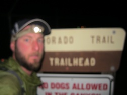
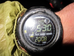
I got started from the trailhead at 5:30am after taking the requisite start photos and footage. For the first 6 miles the trail follows a predominantly flat gravel access road which helped a bit on the break in process. Largely I was thankful that the weather stayed cool and overcast for the entire day. I was worried about the heat given the lower elevations at the start and a long burn section the trail goes through during Section 2. With the winter not producing an average snow pack, I was expecting to see lower than average water source levels as well. This was confirmed when I crossed dry Bear creek at mile 8.6, the first on trail water source. I was banking on getting water at this source and was near empty by the time I reached it. Luckily I was able to find a small stagnant puddle along West Bear Creek that had a nice oily film on top to hold me over until South Platte Creek, 8mi further. Lots of bears sighted along Segments 1 and 2. There’s a long 10mi water carry from S Platte to the Fire Dept Station at Hwy 126. It was definitely less than ideal to have to carry any extra water at this point in the trip knowing that each additional liter of water adds another 2lbs to my pack weight. I generally try and carry as little water as possible and arrived at the Fire Station parched to say the least. I usually take a 20-30min meal break every 3 hours in order air out my feet and take in some calories. They were more than welcomed the first 2-3 days given the higher than normal pack weight I was carrying. Each time I took a break, the pack would drop to the ground with a soft thud. The terrain the first day was fairly gradual in nature, which I was thankful for. I was only planning on doing 35 for the first day, but had those miles in by 5-6pm and was feeling really good still. I decided to push on and with the first’s days excitement was able to get over 43 miles in, which I was really pleased with. With the pack weight I was carrying, I knew I was either going to wake up really sore and regretful, or that it was a good indicator of things to come.
Day 2: Payne Creek Tr - 1.5mi past Glacier Ridge Rd 42.0mi, +6400’
Unfortunately two things were confirmed last night. I indeed had a ‘faster than slow’ leak in my sleeping pad and that 5am wake ups were going to be the bane of my existence. One thing I didn’t take into consideration was how even a 1hr time change from PST to MST would have a noticeable effect on me. For some reason, waking up at 4am, which is how it felt to my body, feels so much worse than waking up at 5am. The lack of comfort from the deflated pad wasn’t helping matters much either. I’d say I probably got 11 minutes of sleep last night on top of the 6min the night before. Needless to say, I was moving rather slow in the morning. My normal 3-3.5mph pace was reduced to a groggy 2mph for the first few hours of the day.
It was interesting the first few days to know just how hard to push myself. The last thing I wanted to do was sustain an injury and besides, Durango was still a long way off, mentally and physically. In knowing that 40mi days were feeling reasonable and that each day another 2.75lbs of food would be coming off my back, I decided to just keep it mellow the first half of the trip and adjusted my strategy to do at least 40 miles if possible, but not hike past 10pm. I wanted to ensure that I was going to get at least 7hr of sleep to help aid in recovery and making sure I didn’t burn out too fast too soon. By day 2 I decided that 5am wake up weren’t going to work for me and had to adjust my schedule to hike later into the night. I compromised with 6am wake ups and hiking to whenever I got 40 in, but not going past 10pm, at least for the first few days.
The views started to open up by segments 4, 5 and 6, particularly through the Lost Creek Wilderness heading towards Kenosha Pass. Unfortunately darkness had fallen by the time I got up to the Continental Divide at Glacier Ridge Rd, but I got to enjoy the last slivers of daylight on the climb up. Dusk is probably one of my favorite times to hike during the day. There is a sense of closure to the day and the lighting is always good. Unfortunately for this trip though, it usually meant I still had another 2-3hr s of hiking to do. Night hiking does something weird to your depth perception. I would find that after an hour or so of night hiking I would almost have the sensation that was was drunk, or in a dream. My eyes would always feel heavy nonetheless, so it always took some additional motivation to keep going when the sun fell.
I got my first sense of motivation just shortly after crossing Glacier Ridge Rd. A Trail Angel had left a cooler of sodas for CT/CDT hikers to partake in. I for one don’t consider ‘trail magic’ to be support, so it was a welcome surprise after 40+ miles of trudging. Some may disagree with me on whether or not ‘trail magic’ constitutes a form of ‘support’, but in my mind it’s nothing that was pre-arranged and I have no more control over it than I do the weather. Plus it’s part of the culture of distance hiking and one of the reasons I love it so much. HYOH!
Day 3: Glacier Ridge Rd - Janet’s Cabin 40.3mi, +7500’
Day 3 would mark the start of the rains for me and the trend of oversleeping. I don’t think I got going until 7am that morning. I could see things building pretty early with the weather that day and knew things were going to settle in for longer than the usual afternoon thunderstorm. Today would mark some familiar territory that I had encountered along my 06’ CDT hike. From Copper Mountain through Twin Lakes, the CT and CDT share the same tread. There’s some advantage to traveling through familiar terrain in that it’s a bit more relaxing in the respect that I have to do minimal navigating, but for some reason it always takes longer to get to the places I’m expecting to get to. I think my mind edits out sections of trail and then stitches together a shorter, more streamline version in my head. This can be frustrating when you’re expecting to be places faster than you’re arriving.
One of the coolest things I passed during the day was a sled dog kennel along the Swan River area. I work with sled-dogs in the winter out of Tahoe, and the dogsledding community is a pretty tight knit group of individuals, so it’s always exciting to come across a fellow musher or kennel operation. I’m assuming this was the kennel that operates out of Breckenridge.
Lots of day hikers around the Hwy 9 corridor surrounding Frisco and Breck. I was really excited to be going over the Ten Mile Range, and later Searle Pass. The climb over the Ten Mile Range kicked my ass for sure. It was the first time over 12,000’ and the trail can be rather steep in sections. Unfortunately, the trail only went along the crest for about a 1/4mi before descending. All that elevation gained for nothing. That was one thing I noticed about the trail. It would either be really well graded and built in some areas and then steep and eroded in others.
The rains came in by late morning, which meant on again off again with the poncho all day. Things did clear up briefly as I went over the saddle atop the Ten Mile Range, but then settled in for good by early evening. Setting up and breaking camp in the rain is not high on my list of favorites, but luckily I remembered there being a cabin just off the trail directly below Searle Pass. So this became my destination and goal for the day. Nothing quite motivates like the possibility of getting out of foul weather. By 10pm I was passing the side trail heading to Janet’s Cabin. I could see a light on in the distance, which is both a good thing and a bad thing. I was hoping just to sleep on the covered porch, but not very many people like to be startled at 10pm in the middle of the woods on a dark and stormy night by a man wearing a poncho. I discretely slept under the firewood shed instead. Good to be out of the weather.
Day 4: Janet’s Cabin - Mt Massive TH 43.7mi, +5800’
More grey overcast skies in the morning with lingering rain clouds. My body was surprisingly feeling really good each morning and even at the end of the day I was still feeling fresh and without any alarming aches or pains. The interesting thing has been trying to figure out what to supplement as a sleeping pad each night. Still not getting any form of descent sleep, I’ve at least been able to curl up into the fetal position onto something resembling padding by using the back panel of my pack and the inflated frame sheet. The extra food bags have been adding some elevation for my head and feet at night, but this set-up is far from any form of recommendation for comfort. The main thing I’ve been trying to do is insulate my body off the cold ground because not getting any sleep AND being cold all night is a recipe for grumpy pants.
The CT took its first contouring route above treeline today between Searle Pass and Kokomo Pass. Early morning light made this more enjoyable even if it was still drizzling from the night before. I knew I would be able to get out of the weather for break in the abandoned military bunkers at Camp Hale that lie ahead. Oddly, I believe I can confirm the exact same turd that was left defecated there in 06’ as the one I saw again here in 2012. If not, I think we have a case of an habitual turd dumper on our hands. I would love to live a day in the shoes of the person that wakes up in the morning and says ‘well, I think I’m going to go shit in an abandoned building today’. Needless, I had to decide if I was worse off taking a break in the rain, or sitting indoors next to a petrified turd.
The hike over Tennessee Pass was pleasant as the weather finally broke for a few hours. The Pro-Tour cycling race was apparently heading over the pass later that day, but it seemed like I was going to miss the peloton by a few hours. It was nice to see a crowd of folks gathered on the pass to cheer them on. Again, another Trail Magic cooler just after the pass was a pleasant surprise as well. Soda number 2. This time a Root Beer.
The weather did come back in again by 4pm, and this time in much harder waves. I resorted to setting up my tarp to cook dinner under. The temps were really dropping this time, so it was of utmost importance to keep moving to stay warm after my break. I did come across a group of 4 individuals who looked like they were about to have an epic of their own. Apparently looking for a place called ‘Uncle Buds Cabin’ it wouldn’t be until later that evening when I re-looked at the maps that I realized they still had over 7mi to go and it was about 6:30pm when they passed me going the opposite direction. None of them had any rain gear on, and all had resorted to wearing all of their dry layers to keep warm. By the size of their packs I would say they definitely didn’t have a shelter and probably little to no sleeping bags. I have a feeling they parked at the wrong TH and probably tripled the amount of miles they were planning to hike. It makes my mini-epic of trying to set my tarp up in the rain after thinking I’d lost the guidelines seem paltry. Latest night yet having arrived at camp by 11pm. Mini celebration having finished off my first of three, 12lb food bags.
Day 5: Mt Massive TH - North Cottonwood TH 40.1mi, +6700’
I intentionally slept in this morning. Between the weather and being well ahead of schedule I decided on a 7am wake up, but would intentionally shorten my breaks all day to balance out the time difference and ensure I put in some decent miles. Still drizzling by morning, so not the most inspiring start to the day. I had passed another CT hiker by the dam at Twin Lakes who said he heard from a locale that the weather was planning to ‘flash floods in the Gunnison area over the next three days.’ Awesome.
Ironically it cleared up the rest of the day. Eye of the storm I thought? I have to be honest here and say I think the CT and Colorado in general is better suited for mountain biking than hiking. It was a bit of a disappointment how much time the CT spends below treeline, especially when it deviates from the higher and more scenic CDT. Today was when I realized that for the first time. The CDT through this section takes a higher and arguably more scenic route over Hope Pass while the CT contours along Hwy 24/285 for the next 50 miles until crossing Hwy 50, almost entirely in the trees, minus a few short sections over some saddles. It does pass within eye shot of a few 14ers through the Collegiate Wilderness, which has some redeeming factors, if that is your thing. I would like to see the CT and CDT become one entity over the next few years where they share similar corridors. At least then you are getting the trail maintenance efforts of two organizations for the same trail.
Which brings up another point about this section that I would like to applaud. Earlier in the year, it was this section, Section 12, that was closed off entirely due to excessive blow downs which the Forest Service estimated would take years to reopen. Over the course of a long weekend, the efforts of some 70+ volunteers came out to clear the 300-400 blow down that had been caused by a severe micro-burst storm in the area. It was really impressive to hike through that area and see just how many trees came down over the trail. To think about crawling over, under and around each of those blowdowns would have been a nightmare. My thanks and praise goes out to all of those folks who were involved!
The rejoicing was short lived once the rains came back in by the afternoon, but all was not lost when I was able to sleep in a TH privy that night at the North Cottonwood TH to get out of the weather.
Day 6: N. Cottonwood TH - CO Rd 225 43.6mi, +7100’
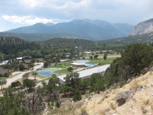
Today was probably the hardest day mentally. Not so much because the hiking was hard, mainly it had more to do with the close proximity the trail takes past some public pools and water slides in the Mt Princeton area! The trail drops back down to 8000’ through here and the sun came out just in time to get a good sweat going. It takes a lot of self restrain when you’re dusty and grimy not to hop a fence and run the 30yds through lush grass onto the water slides.
I did come to a major decision while I was making my way down through the Mt Princeton area. I would be passing the halfway point today and was banking on the second half of the trip going faster than the first. I began the trip with roughly 13 days of food rations and was wagering that I should finish in under 12 days, conservatively, at this point. I was thinking that I could probably actually get rid of some food. Sounds ass backwards I know, it shocked me too. I was thinking all along that I would be starving and just getting by on my rations, but in reality the food I packed was sustainable and fulfilling, almost too much food per day. If I could throw out even just one day’s food rations, that, along with some extra trash I’ve been carrying around, would probably mean at least another 2-3lbs off my back, which is always a good incentive. In total I think I threw out 2 dinners, 8 bars and 2 bags of trail mix. Probably about 4,500 calories in total. I know, crazy!
I did take advantage of the Mt Princeton general store by picking up a tube of sealant for my sleeping pad. Six nights of restless, uncomfortable, sleepless nights were beginning to take their toll and I knew I would need the insulation heading through the higher and thus colder San Juans that lie ahead. Again, this is probably a grey area in the realm of support vs unsupported, but I made the decision to repair my pad and would do so again. I see it as more lost time to make the purchase and do the repair than it is to increase my pace or decrease my overall time in anyway.
Passed the halfway mark around early evening through the day, marking my time at 5D13H45M. My goal for the day was to get at least to Hwy 50 (mile mark 252.5) which would put my daily average at 42.1mpd. By this point my pack was beginning to feel much lighter and something I was much more attune to carrying; probably in the neighborhood of 22-23lbs. I set a personal goal at the beginning of the trip of going sub-12 days, but having just passed the halfway point and feeling good about my current state of health, I was feeling really good about trying for sub-11 days. That would mean needing to average more than 46.5 mpd. I knew in reality I could probably average slightly less than that and then just put in one long marathon day at the end. Something less than 75mi would be ideal. In keeping at my current pace, that would mean putting in a 65mi day at the end. I thought this was realistic, but I knew that for every mile I put in over 42 in the next few days, would mean that much less to do on that very last day. So the motivation was there to pick up the pace.
One thing that was concerning me, though, was a slight cramp I was getting halfway through the day in my right calve. It was hard for me to tell if it was a muscle strain or possibly just some low sodium levels that were causing the cramping. Beyond that, my feet were doing fine, minus some slight blistering I was starting to get on the outside of both my heels. Blisters have always been something I rarely get and when I do, I can walk through if needed, but joint and muscle pain is always something that alarms me because of the long term effects it can have.
Day 7: CO Rd 225 - 0.5mi past Upper Razor Spring Tr 41.8mi, +6100’
The next day and a half’s worth of miles would take me back up onto the Continental Divide, which can be really scenic on one hand, but it’s access to reliable water sources can become problematic. The Cochetopa Hills in particular can be one cow infected water source after another.
While looking over the maps the prior evening I was curious to know if I would recognize the junction where the CT and CDT met back up. As soon as I hit the saddle on the Divide there was a wave of memories and visuals that came flooding back. The section of the CDT between Monarch Pass and Marshall Pass is probably one of my favorite sections along the CDT through Colorado. It’s high, open and expansive, with great contouring and good footing. All the ingredients for a great day hiking. That day there was also the ‘Monarch Crest Crank’ charity ride taking place, which, after talking to some participants, is an annual fundraiser against domestic abuse in the nearby town of Salida. It was fun trying to keep pace with the mountain bikers, as I’d usually pass them on the uphills and then they would come zipping past on the downhills. In the 5.5mi our paths overlapped on our way to Marshall Pass, I think I was even able to finish ahead of some of the riders! The ladies at the aid station even threw me some apple and orange slices which was a nice treat!
I would need that sense of elation and companionship to get me through the rest of the day along the dry and rather boring start to the Cochetopa Hills. From Marshall Pass it’s a long and hot 12mi stretch without water to Tank Seven creek, followed by another 22mi stretch to Lujan Pass. I opted out of the 1/2mi detour to get water at Baldy Lake as adding any frivolous mileage at this point was out of the question. I’d rather be thirsty than hike a mile out of my way. Thankfully, the timing of that waterless stretch had me doing it in the cool of the late evening into night fall. I ended up dry camping on a minor peak just past Upper Razor Creek Tr, leaving just a few downhill miles in the morning to reach water. I was hoping to get more miles in today, but to no avail.
Day 8: Razor Creek - Bondhold Meadow 45.3mi, +5700’
The goal today was to get as far into the high country of the San Juans as possible. The prior day I could see San Luis Peak (14,014’) sitting far in the distance. One of my favorite things about distance hiking is seeing some landmark far in the distance in the morning, and then slowly over the course of the day, getting to that landmark or having surpassed it. Today was no exception. By nightfall I was cresting the saddle of San Luis peak and descending to find a suitable campsite. Too bad the best thing I could find was more or less sleeping right in the trail itself.
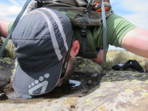
Most of today was along dirt roads and 2 tracks, which generally translate to quick miles. I think for most of the day I was able to travel at or above 3.5mph. When you’re making good progress, the day seems to pass by that much more quickly. Lots of cow pie water to drink today. Not much of an option sometimes when that’s all that’s around and its miles until you’re going to pass something else. Cow pies don’t even faze me anymore. I’ve probably drank more cow shit infected water in my lifetime than should be recommended. I’ve never had an adverse reaction to it, even though I never treat my water. How ironic would it be if cow shit water ended up being the fountain of youth? Bottles water companies would have a field day with that!
Lots of threatening clouds in the sky today. Apparently it must be the start of some hunting season given the amount of camo that’s been spotted over the last couple of days. Its always amazing to me how decked out some of these hunting camps are. I think they’re nicer than some people’s homes. Heard the first elk calls today and scared off a huge brown bear in the Cochetopa Creek drainage just before San Luis saddle. Awesome feeling climbing over the saddle under the nearly full moon. I couldn’t see the peaks around me, but could tell they were craggy based off of the silhouettes the moonlight was casting.
Officially I have eaten my way through 2 entire food bags. That’s over 25lbs off my back since the beginning of the trip. My pack is at the point now where I have to intentionally pack it haphazardly in order to try and fill it up. In the next day or two I should be able to fully cinch it down, including the compression straps on the side, without much effort. Both my MP3 players have died today though. I’ve been intentionally rationing the battery life each day with hopes of having tunes all the way until the end. I guess it probably didn’t help that I left one player run all night long, forgetting to turn it off in my tired stupor. Off to bed by 11pm tonight.
Day 9: Bondhold Meadow - Cuba Gulch Tr 44.9mi, +8400’
When I made camp last night I could see a campfire roaring on the adjacent hillside just before I made camp. I thought I would end up passing my friendly neighbor’s camp sometime early the next morning, but they apparently were the early birds that morning. I was awaken at 5:30am by footsteps lunging over my head. Given that I pretty much slept desperately with my head in the trail that night, I couldn’t blame them. My guess was that they were going to climb nearby San Luis peak, one of Colorado’s 14ers.
This stretch through the San Juans I remember fondly from the CDT. It’s uber-scenic, but it’s an ass kicker of a day. It’s one 1000’ climb after another as the trail meanders from one river valley to another. The trail is anything but graded efficiently either. Generally it will go straight up the hillside, maybe an occasional half-assed switchback thrown in for wit and irony. The crown jewel, in my opinion, is the stretch that cuts across open Snow Mesa. At 12,000’, you get expansive views into the southern San Juan with very little effort or change in elevation. There was a shepherd tending to his flock of sheep as I was passing through and I got to lay witness to his amazing border collies taking commands. The weather couldn’t have been better for the beginning part of the day as well.
I passed another CT hiker early in the day as he was breaking down camp. Apparently he graduated high school in Durango and is hiking the Colorado Trail all the way from Denver to his 50th high school anniversary. If you do the math, that puts this guy at 67-68 in age. Pretty inspiring effort, especially given that he didn’t look a day over 55!
I made one dire mistake while descending to Spring Creek Pass though. For some reason I was thinking that the creek flowing off the Mesa would be flowing, but in hindsight its marked as a season flow on the map. That small mistake meant that I would be carrying about 1/2L of water around 13mi till I could get to the off-trail source at Rd 547. Whoops. Luckily the clouds rolled in for the afternoon which would take some of the edge off of the heat of the day. The Divide follows a lot of dirt roads and two tracks through this section, so there was an ample supply of mud water to be had in puddle form but I wasn’t that desperate yet. I was able to find some shallow clear pools sitting in rock depressions that I was able to sip from along the way. I would estimate that I was able to drink at least another liter in this manner. It’s amazing how good water tastes when you’re thirsty. I guess I should probably pay better attention to the maps too.
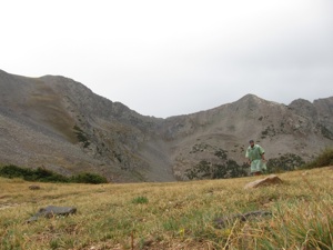
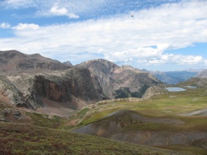
The section leaving Spring Creek Pass all the way to the end is by far the highlight of the Colorado Trail. You are literally walking the Divide for a lot of it and the views are endless. It does take a lot more effort though, given that most of it is above 11-12,000’. I crossed the highest point of the entire CT today on an unnamed peak at 13,200’.
All day I was getting flashbacks of my 06’ hike through here of getting snowed out and hoped the same wouldn’t happen this time. One thing I was really excited for was heading over the new high route section between Cataract Lake and Elk Creek. This section was being built in 06’ and the weather was not favorable then for a cross-country high traverse, so I had to opt out and took a lower route. I ended up cresting the saddle above Cataract Lake right at dusk and was debating if I wanted to do this section in the dark or camp early and hike through in the daylight the next morning. I only had about 37-38mi in at that point so part of me knew that was one of the compromises in attempting this speed record and the other part of me thought I would regret missing one of the highlights of the entire trail. I decided to push on and it ended up being one of the best decisions I could have made. At some point in the night, the overcast skies opened up and the nearly full moon was able to illuminate almost the entire area. For most of the night I was able to hike without a headlamp. I wasn’t able to see the grandeur and fine detail of the distant mountains, but the ambiance was enough to justify the decision to push on. Some parts of the trail were only defined my cairns spaced every 100yd or thereabouts, so route finding became a little tricky in spots, but I told myself as long as I can keep connecting the dots with these cairns I’ll keep walking. Worst case I could always post up early and wait till morning to find the trail.
All in all one of my biggest days yet with almost 45mi in and over 8400’ in elevation gain. The biggest motivating factor was getting to the 100mi remaining mark. Hiked to 11:15 and consumed 1200mg of Ibuprofen for the day. Balls of my feet are really starting to get sore with the longer days and the blisters on my heels seem to be getting worse. The end is near though.
Day 10: Cuba Gulch Tr - Bolam Pass TH 46.4mi, +6100’
Coldest night of the trip so far. Overnight low of 36 degrees. Makes getting moving in the morning that much less motivating. So glad I was able to repair my sleeping pad. I couldn’t imagine how cold I would have been if I needed to sleep right on the ground. Been sleeping in all my clothes which isn’t anything more than a puffy and beanie and setting up the tarp each night in an effort to maximize heat.
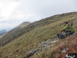
More stunning scenery today through Stony Pass and into the Elk Creek drainage. The view from the head of the Elk Creek drainage is probably my personal favorite along the entire trail. Rich in an array of colors, there are two alpine tarns that are perched on the bench high above the rest of the canyon floor. A few relic mining cabins remind you that you’re in the mountains of Colorado.
All day I hemmed and hawed about how far I wanted to go today. At one point I was even considering just going straight though the night and not stopping until I reached trail’s end. Hindsight I’m glad I opted out of that choice. Those types of ideas always seem really good early in the morning when I’m feeling good and fresh. Ask me the same question when I’m on mile 45 at 11pm at night if I want to put another 50 in and you’ll get a different answer. It was great to pass the 400mi mark early in the day. Again, the more I put in today the less I have to do tomorrow.
Off and on rain again all day. Got to finally see the much hyped about train that goes from Durango to Silverton. It looks like it would be a scenic ride, but it will have to wait for another time. It was a little disheartening crossing the Animas River knowing that it flows downstream directly to Durango, while my trailed route would take me another 85mi to trail’s end.
You can really see the landscape start to change around the Molas Pass area. It begins to look like a more lush version of the desert southwest. More sheep grazing above Molas Lake. Was able to throw out some more trash at the Molas Pass pullout on Hwy 550. Every ounce I can ditch at this point seems to be in my favor, so anytime I can ditch some trash I’m all for it.
The trail does some excellent contouring west of Molas Pass and appeared to be really scenic. Unfortunately it was dark by the time I reached the Rico-Silverton Tr junction. Earlier in the day I set a goal of trying to get to the Bolam Pass TH, which would put me at 46 for the day. For me, it’s more motivating to get to a known point each day, than to hike a certain amount of time. I look at each TH as an opportunity for something. Maybe a covered picnic area, an outhouse, a trash can. Something that could help me out or be an advantage. Usually there’s nothing there, but there’s always the hope.
I hiked till nearly midnight and spent a good 4+hr walking in the dark. Tonight more than even I felt disoriented and ataxic. I think I’m hitting my threshold for lack of sleep. I just keep telling myself one more day. It seems surreal that I will finish tomorrow. The rhythm of the day has become so habitual at this point. Wake, walk and eat. I’ve been cutting my breaks down to 15-20 minutes in an effort to maximize my sleep at night. I can tell I’ve lost weight at this point,maybe 5-10lbs, but have been surprised how suppressed my appetite has been. I’ve been eating a lot, but I don’t feel ravenous. Without music I feel like I’ve been running out of things to think about. Anything to keep my mind off the time or how many miles I need to cover yet. I’m a little worried what my body will feel like in the morning, but there’s only one more day and 53.3 miles to go.
Day 11: Bolam Pass TH - Junction Creek TH 53.3mi, +4700’
This is it. All I keep thinking about all morning is that if it took me till midnight to do 46 last night, that means its going to take me till at least 2am to get 53 miles in. God that sounds awful. Six to seven hours of night hiking? No thanks. Oh, and I slept in as usual. I’ve pretty much abandoned the idea of every waking up before 5:30am again on the trip. Good thing I never have to. Didn’t hit the trail until 6:45am, but the fear of hiking till 2am was my motivator all day. I felt like I was constantly monitoring my pace today. It’s hard to tell when you’re tired what feels fast anymore. Usually I can tell my pace down to the tenth of an hour. Today everything felt slow.....and fast at the same time.
In my sleep deprived state, I made yet another mistake with calculating my water needs. For some reason I thought I was past all the waterless sections and that my water concerns were over. Next thing I new I passed my last water source for 22 miles, Straight Creek, without filling up. I thought about turning around, but again, any extraneous miles at this point was out of the question.
When the trail crossed Rd 564, I opted to continue down the road in search of water, given the fact that the trail parallels the road for the next 5mi and the trail crosses the road some 4-5 times. In general you can usually find more seeps along roads because of the nature of cutting into the hillside to grade the road. Within a half a mile I first found a half full bottle of water covered in mud that someone obviously had thrown from their vehicle. Sweet! There’s 10oz of water to add to the cache. About another 1/2mi later I was able to find a seep that was flowing through a storm drain under the road. I downed two liters on the spot and then carried another liter out of there. It worked out perfectly to rejoin the CT at the 1st crossing, having paralleled the trail for about 1.75mi. Disaster averted. Hindsight I should have carried more than a liter away from that seep because I still had another 15mi to get to Taylor Lake. But that’s what happens when you’re brain isn’t working fully.
I was even having trouble following along to my exact location on the map. The trail follows a ridge for a good many miles and all the saddles and peaks start to blend together. The trail crested one last high point at 12,200’ before making a long descent to the Junction Creek TH, but not before doing a series of peak to saddle climbs and descents. I could see my route extending far down the ridge ahead of me, which didn’t help inspire any motivation when I saw how many more peaks and saddles had yet to be attained. To my benefit, I came upon the Shark Tooth Tr junction about 2 saddles earlier than I was expecting. It was such a relief to not have to gain the elevation that lay ahead of me. Instead I could descend to Taylor Lake and then ultimately to trail’s end.
I made great time to Taylor Lake, having covered some 31mi by 5:15pm. Took a swim in the lake to get refreshed and trying to rejuvenate the legs for the remaining 22 miles. When I crossed Kennebec TH I ran into a local who was enjoying the sunset and who had obviously down a few beers. The following conversation that ensued was probably one of the funniest I’ve ever had along a trail. Here’s the gist.
Drunk Guy: “Where you hiking from?”
Me: “Oh just passing through, started in Denver”
Drunk Guy: “GOD DAMN! What the hell you doin’ that for?”
Me: “Oh, just for fun”
DG: ....blabbing on about something and then mid-sentence....
“GOD DAMN you got some huge calves! Anyone ever tell you that?”
Me: “Yeah, i’ve been told that before, I credit my mother”
DG: ....staring obviously at my legs for the rest of the conversation....
“Golly, look at them things. I’ve never seen calves so big on a guy your size”
“ You know, actually now that I’m looking at em’, they look kinda WEIRD”
“ Yeah, sumthin’ just don’t look right”
Me: “Ok, well I got to keep going, you take care”
Amazing what you’ll run into on the trail! From there until the end is just a blur of drizzling rain, pointless climbs, overgrown trail and delirium. By the time I got to Sliderock Canyon it must have been around 9pm and I still had 12mi remaining. I took a break and soaked my feet in the cold stream for as long as I could stand it. I made the mistake earlier in the day of peeling the tape off of my heels only to reveal some juicy blisters about the size of a quarter. For some reason I thought it to be a good idea to drain one of them. Big stinging mistake. Since then, I’ve just been trying to nurse my feet to the end. I started counting down the miles in my head once I dropped into the single digits. The last 5-6 miles felt like forever, especially given the fact that the trail makes a pointless 1000’ climb out of Junction Creek, only to rejoin it 12 miles later. Once I hit junction creek for the last time I only had 2.5mi to go and began to perk up. It’s amazing how much adrenaline can make pain disappear. Somewhere between the effort in just wanting to end it and the impatience of the mileage taking far too long, I began to jog with about 1/2mi to go. And then that was it. I was standing in a trailhead parking lot at 12:35 in the morning. No applause, no cheering, no parade...... and it was perfect. I had met my goal on my own terms and in my own way. After the requisite photos and footage for documentation I took a short stroll down the road towards town to get my bearings for the morning. And that was it. I turned around and found a place to camp like I’ve done all the previous nights. Only tonight I could go to sleep without any guilt of oversleeping.
Fuel for the Hate Game
It an effort to be as transparent as possible and to keep all things as fair as possible, I’ve included a list of details around the specifics of my hike. If you have any questions or concerns about the validity of my hike, please feel free to contact me. To view my SPOT track, click on this link. I’ve also included a Google Earth file you can download.
-
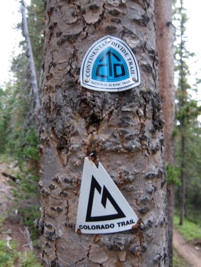
-For navigation I used Erik the Black’s CT Atlas with a measured distance of 484.7mi
-
-I did not have to take any prescribed reroutes or detours due to fires or trail closures.
-
-I carried all of my food and fuel supplies from the beginning, 13 days worth at 37lbs
-
-On 4 occasions I partook in ‘Trail Magic’ consisting of 3 sodas and a few apple/orange slices: Glacier Ridge Rd, Tennessee Pass, Chalk Creek TH, Marshall Pass
-
-I purchased a repair kit for my sleeping pad at tme Mt. Princeton general store
-
-I threw out trash along the way
-
-Twice I sought the use of non-carried shelters; i.e pit toilet @ N Cottonwood TH, Janet’s Cabin firewood shed
-
-I used any pit toilets along the way
-
-On day 2, I paced with another thru-hiker (unbeknownst to him) for about 2 miles. All other times I hiked by myself.
-
-On 4 occasions I diverged from the official CT and took a parallel route. This was usually done to access water. No divergence was any shorter in overall mileage.
-
1)Hwy 126 Fire Station - After filling water from the fire station, I followed the hwy back to where the trail crosses Spring Creek rd ~ 300yd
-
2)Camp Hale - Followed rd 714 from Cataract Falls to the Camp Hale TH ~ 1.4mi
-
3)Rd 534 - Detoured from road in search of water. Paralleled CT from 1st crossing to second crossing of rd 534 ~ 1.8mi
-
4)Rd 547 - Descended from CT to find water and rejoined ~ 1.5mi
-
-I would ask locals and other hikers about current water and weather conditions
-
-i carried a SPOT device for verification to to continuously track every 10 min
-
-I carried music to listen to along the way
-
-I threw out un-needed food supplies along the way
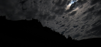
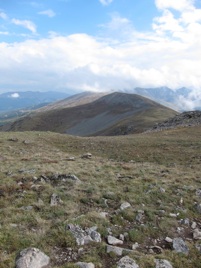
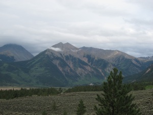
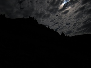
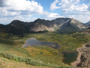
(left) With views like this, putting in long hours into the night is much more enjoyable when your body aches and your eyes are heavy. West of San Luis Saddle, San Juan Mountains.
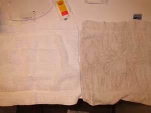
Why you should charge extra to let a thru-hiker stay at your hotel! (left) A clogged drain from 11 days of dirt and grim. (right) This washcloth will never be white again!


